One potential response to a crisis you might choose to employ is bugging out. Evacuating, fleeing, getting of dodge, whatever you want to call it, your success or failure will be predicated on knowing where you are going and just as importantly how’ll get there.
Travelling during or immediately after a crisis is not going to be as risk-free as a trip to Disney World and the stakes will be far higher.
Obstacles and setbacks will be numerous, and knowing where they are, where they potentially might be and anticipating other hazards will be crucial.
Getting lost or turned around will be a significant risk all on its own; you may not have your first choice of road, and familiar signs, waypoints and markers could be obliterated or obscured.
For all of these reasons, like every other thing we undertake to be prepared for those rough patches in life, you should take great care to plan your routes that will use when the time comes to hit the road.
In this article, I will provide you with specific steps and considerations to make use of when planning your bug-out routes. On foot or by vehicle, this information will help you plan efficiently and intelligently.
So break out your maps, markers and pencils and let’s get started.
Why Have Bug Out Routes At All?
If you know where you are going, you simply go there, right? Maybe, maybe not.
Like I mentioned in the opening paragraphs, travelling a route under duress from an existential threat is far different than driving the winding mountain roads to Uncle Bill’s cabin by wrote memory, or following a hiking trail by landmark on a pleasure-filled day in a national forest.
Sure, your memory may be infallible when you are calm, and some disaster has not potentially altered the landscape, clogged your route with fellow evacuees, or rendered your path(s) impassible from damage or mayhem. That kind of travel is a whole new endeavor!
And the pressure will, as they say, be cranked up: delay or failure could mean having to ride out a very bad situation, or potentially even death, and the deaths of those with you.
Avoidance and escape is often times the best policy, and accomplishing that end will mean a greater chance of survival when things go pear-shaped.
Travel during a bug-out may mean detours, going off the beaten path, dodging a multitude of hazards and more fun maneuvers.
You need to know not only where you are going, but what route you’ll choose to get there, rain, shine, snow or rioters be damned, and what hazards and snags you can expect along the way. That is an awful lot of info to keep in mind and recall under pressure.
Sure, if you are a long time local, a ramblin’, scramblin’, travelin’ type, you might know every highway, road, street, alley, path and trail in your county, and have intricate, borderline encyclopedic knowledge of all of them. If that is you, I envy you sir or ma’am, and salute your expertise. For the rest of us, the point I am trying to make is write it down!
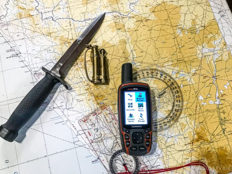
To do that properly, you’ll need a map. In the next section, I’ll show you how to do just that, and then get into the details you need to know backwards and forwards for planning your route no matter where you live and where you are heading.
Map It!
To effectively plan your route out of town (or rather, from home) to where you will hopefully be safe, you need an appropriate map. The kind of map that is best will depend somewhat on where you live, where your BOL(S) is/are, and how you plan to get there.
If you live in a built-up area, metropolis or major city, you should get a detailed map of your locales roadways out to at least the suburbs if they exist. If you live in a rural or remote area, you can do with a simple areal road and highway map.
This is where you might need additional maps depending on the distance to your BOL.
A large city and an accompanying map that has enough detail for effective planning will likely not “reach” all the way to your BOL, necessitating another map that does show the way to your BOL.
Similarly, a wide-area map of your neck of the woods showing contour and terrain lines may not have comprehensively listed roads and highways on it.
It is up to you to ensure that your map has enough detail of the areas you’re living in and headed for to be useful for route planning purposes. Once you have that map, or maps, you are ready to sit down and hash out your routes.
Necessary Factors
Before you trace your primary and only route out of town in green sharpie like its 1st grade coloring time, put the cap back on that thing and listen up for a minute. Your route planning can be as detailed or as sparse as you’d like it to be.
Some people like a lot of detail and markup, some people want only the essentials and little else. Some preppers want a primary and alternate route to a given location, but others want three or even four routes marked up for each potential BOL.
Consider also how you will be moving: do you plan on taking a vehicle, or is on-foot travel a possibility? How would a choice of bicycle or motorcycle affect your route choice, would new routes be open to you?
How many people will be with you and do they have any special requirements that will restrict your speed or affect your route choice? Do you have multiple BOLs, and are they in differing areas or do they all lie more in less in the same region? Are they located in different cardinal directions?
Carefully consider how the type of crisis might affect your route planning.
Will a weather event destroy or block roads? Is a rapid-onset event, man-made or natural, likely to send panicked herds of people onto the roads, clogging them utterly with traffic?
Would an event occurring in a nearby area constrain your choice of safe area to only one or a few practical ones?
However much or little you do is totally at your discretion, but I would offer you a few general guidelines to ensure you are “baking-in” effective bug-out plans for your route choices should they be rendered unusable or likely unusable.
Create Escape Routes Away from Your Home in All Directions
If practical. Remember, you will likely have some warning of what you are facing from news and emergency broadcasts on TV, radio, internet and other sources. You should obviously use that info to inform your imminent departure.
If a man-made disaster or social upheaval has sent throngs of quarrelsome people into the streets in one part of town or along one of your escape routes, don’t think twice and don’t even try to go around it; you can head squarely away from trouble if you have your BOL’s evenly distributed.
The same advice goes for natural disasters like wildfires or approaching severe weather. Head away from it, not through it!
Have Redundant Routes for Each Bug Out Location
As the saying goes, don’t put all your eggs in one basket. You might simply be unlucky enough to encounter a blockage on your way to what could be the ideal safe place to wait out whatever it is you are running from.
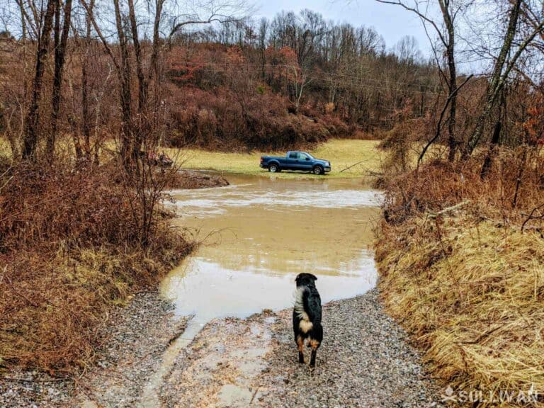
A car crash, downed power pole, flooded trail or some other mishap could stall your forward progress, but that is not an indictment to simply turn around and go back to whence you came.
If you have taken the time to plan and mark your routes, you should easily be able to detour around the obstruction and carry on your way.
This is the same for on foot travel as it is motorized travel. You never know what unexpected and unforeseeable obstruction you might have to deal with.
Note Alternative Lines of Travel
Especially important when bugging out by foot. Things like train tracks and rivers are generally not going to be destroyed wholesale and can serve as valuable navigational aids in a pinch.
Definitely take the time to learn the rail routes in your area and where they lead to. If all other means or paths fail, you can simply follow the tracks and be assured of arriving at the final destination.
Anticipate Obstructions and Bottlenecks
Like I said, take the time when planning to anticipate likely bottlenecks along your routes. Cannot think of any? Then you need to get out and reconnoiter the roads, back roads, and trails you are planning on taking to save your own skin! Each and every road and path will be vulnerable to some kind of potential or likely obstruction.
Need some examples? Okay, if you live in a city, any road that is a major thoroughfare and its secondary feeder roads will more than likely be clogged with traffic when the balloon goes up, which means you’ll need to either get the drop on evacuating, or simply avoid them.
How about road that crossed a rail road? What a bummer that would be if a train were to wind up stopped there when you desperately need to go through!
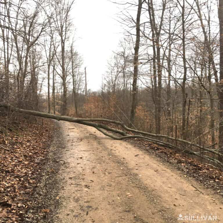
In rural areas, any road with a preponderance of large trees or large diameter power poles is likely to become impassible to vehicles in a severe weather event when they all come tumbling down.
Oh, sure, if the terrain allows it you can just drive around, right? Right. Unless the ground is prone to inundation and turns into an impassible bog, trapping you. Always think three steps ahead.
Also, in rural areas, you should make an attempt to plan a good overland route from point A to B, terrain allowing, or at least shortcuts from one road to another.
While rural roads are less traveled they are also fewer in number, and if they become blocked for any reason you would be well-served by knowing which areas will allow you to reliably drive off-road and reach your destination.
Beware Bridges
If there is one road feature sure to cause consternation it is a bridge. Bridges are easily overcome or rendered unsafe by inclement weather, neglect or human interference in the form of road blocks and demolition.
Being overtaken by a mob on a bridge is especially dangerous, as you have nowhere to go once they have advanced past your vehicle.
Make sure to mark any bridge on your route as a caution point, and especially bridges over deep water.
Avoid Unsafe Areas
City or country, when planning your bug-out route ensure you avoid known areas of disrepute, as these will likely be epicenters of trouble when disaster looms. This could take the form of a neighborhood or borough in a city, or a small village or town known to not take kindly to strangers if you are in the country.
Areas known for political agitation should also be avoided, as the instability caused by the crisis will usually be taken as an excuse for the denizens of such hives to take to the streets and generally be a pain in the ass.
Once again, if you cannot say for certain where those areas are, you must find out and give them a wide berth accordingly.
Avoid Hazard Zones
Definitely be sure to plan your routes around different locations and features that could become secondary hazards depending on the type of disaster you are likely to face.
These zones could be man-made or natural, and will take the form of things like areas prone to flooding in heavy rain events, hillsides or mountain paths that are likely to fail and slide in the same conditions, chemical plants and farms, power stations (especially nuclear ones), and so forth.
Your clever detour that winds up sending you into a cloud of toxic vapor from a beleaguered chemical plant that was hastily abandoned by all hands will just be another way to die or become seriously ill.
You do not have to plan around every, single potential hazard, but you should be planning for the most obvious ones at least, according to what disaster is most likely to befall you in the first place.
Include Potential Safe Havens
You should mark convenient places on your route or close to it where you might potentially “pit in” to get aid or shelter, places like hospitals, government buildings, police and fire stations, and EMS bays.
Now, as far as these buildings go, depending on what kind of crisis you are facing and the severity thereof, you might want to avoid these areas: hospitals will turn into nebulas of contagion in a pandemic or serious outbreak of disease.
Civil disturbances will see government buildings and police stations flocking with protestors and malcontents, and so on.
That being said, it still pays to know where these places are all along your route. Make sure you mark them accordingly.
Understand How Different Scenarios Shape Your Routes
Evacuation planning is not a one-size-fits-all proposition. Your route will be determined by the type of emergency or disaster you are facing.
For example, if you live in an area that is prone to earthquakes, your evacuation plan will be very different from someone who lives in a hurricane zone.
Seasonal weather will also affect your route selection and assessment for better or worse. In the winter, for example, icy roads and treacherous conditions could slow down your escape, or even prevent you from leaving altogether via a given route.
Even high capacity routes that are a good bet in normal weather, like freeways, could become impassible.
In addition, different types of disasters will present different hazards that you will need to account for in your plan. A wildfire evacuation, for example, might require you to leave quickly in order to avoid being trapped by the flames.
What if you are driving across roads already scorched and melted by the fire? How might you change your plans if the route you chose previously goes through a forest that could turn into a blazing inferno?
A tornado evacuation might mean having to navigate around downed power lines or debris on the road. Flash flooding can sweep away cars and even people, so you would need to factor that into your route planning if going by any low-lying areas or ones near major bodies of water.
One of the most important things to remember is that you might not have a lot of time to make decisions in the heat of the moment. You should always rehearse your plan dependent on seasonal conditions and the most likely hazards.
Considering Alternate Travel Routes
Alternate routes and modes of travel might well prove to be invaluable when all other options fail. Following along the railroad tracks, as mentioned previously, can certainly deliver you to your destination as can waterways in the form of long rivers or lakes.
Bugging out via boat or kayak might be a viable option in some cases, but make sure you know the area well and that you have a safe place to put in on the other end.
If you live near a large body of water, this could be a good choice, but keep in mind that bridges may be out or impassable and waterways can quickly become quite dangerous in bad weather.
One thing to consider is having a bicycle or motorcycle as part of your emergency plans. Both are small, nimble and fuel efficient (gas or muscle!).
They can provide a quick and affordable way to get out of dodge, but remember that you will need gasoline and a parts kit for the bike if you plan on using it for an extended period of time.
Both can also pull small trailers or mount saddlebags to give you a little extra cargo capability. Bikes and motorcycles may both prove to be more complicated than they are worth if you have family in tow, however.
Should You Install Supply Caches Along Your Routes?
One of the best ways to make sure you have everything you need along the way is to install supply caches at strategic points along your bug out route. This could include food, water, fuel, tools and other essential items.
Make sure you plan for these caches carefully and that they are not too close together or too far apart. You don’t want to overload your vehicle for a long journey or be lugging a heavy pack all day long, but you also don’t want to find yourself stranded without supplies in the middle of nowhere.
Cache placement is important; you don’t want it to be found! Try to find a spot that is not visible from the road and is off the beaten path but still reasonably convenient for you to access- easier said than done!
You also don’t want to place your cache in an area that could easily flood or wind up being looted.
Some good cache locations include:
Kept a a trusted friend or relative’s property.
- Locked in a storage unit for the purpose.
- Stashed at a business or other property you own or have control over.
- Hidden in an abandoned building.
- Buried in a weather and waterproof container.
Burying your cache is always a good option, but make sure you remember where it is! marking it with a GPS coordinate or other permanent landmark can help make sure you can find it again, even if everything else has gone wrong.
Cache supplies are only useful if they are maintained and rotated on a regular basis. Make sure you check all your supplies regularly and replace anything that has gone bad or that you might not be able to use in an emergency situation.
Fuel and food, in particular, are highly vulnerable to degradation and depending on the specific placement and cover of your cache maintaining these supplies could entail a huge investment of time and effort.
Planning Routes for Convoy Operations
If you are planning on bugging out with a convoy, the same basic planning principals apply, but on a larger scale. You will need to map out your route and make sure everyone in the convoy knows where they are going and what their specific role is.
If you are planning on bugging out with a convoy, you will need to take into account the different bug-out vehicle capabilities within the group.
Not everyone will be driving a 4×4 with off-road tires or a large truck. If you have a mix of vehicles, you will need to plan for alternate routes that everyone can take depending on the vehicles available.
In addition, it is important to designate specific rally points along the way in case the convoy breaks up for some reason. This could be something as simple as a rest stop or a predetermined location where everyone is to meet up in case of emergency.
Make sure you have a backup plan, too- things don’t always go according to plan. If something happens to your vehicle or to the person in charge of navigation, you need to have a way to get everyone back together again.
One of the most important aspects of convoy operations is communications. Everyone in the convoy needs to be able to communicate with each other effectively and understand their role in case of an emergency.
This means having a working knowledge of ham or GMRS radios, walkie talkies or other communication devices and making sure everyone has access to them in every vehicle. Cell phones are, as always, a worthwhile but potentially infrastructure-fragile option under the circumstances.
In addition to radios and cell phones, there are a number of other signaling options that can be used to help keep your convoy together and issue commands or status updates to each other.
One option is to use flags or bandanas, or any other color-coded cloths as a way to identify your position. This is a particularly good option if you are travelling through unfamiliar territory and want to stay off the airwaves.
Similarly visual signals can be issued with headlights or flashlights, particularly at night. If you see a light blinking in a certain, pre-arranged pattern, you know that a vehicle crew is trying to tell you something. You can do much the same with horns or whistles.
As mentioned earlier, convoy operations require a high degree of communication in order to be successful. One way to facilitate this is to use pre-arranged signals to issue commands or updates to the rest of the convoy. This can be a made-up code or signal that is known and used only by you group and can be as simple or as complex as you desire.
Route Planning Contingencies
When travelling along your routes, don’t trust entirely to GPS systems. In an emergency situation, these can easily go down or be disrupted.
Your paper maps and compass (hand held or vehicle mounted) are a good backup and can help you if satellite navigation fails and in any case can help prevent the dreaded “Google Maps Detour.”
Also, make sure you know the area you are travelling in. This might seem like common sense, but in the stress of an emergency it’s easy to get lost.
Knowing the local geography will help you stay on track and avoid any dangerous areas like gang territory.
When travelling in a convoy, it is important to keep the vehicles as mechanically sound as possible.
This means regular maintenance and repairs as needed. If you are driving a long distance, stop regularly for everyone to check their vehicle and make any necessary repairs before they turn into breakdowns.
Large, deserted or abandoned parking lots are ideal for the purpose since you can easily see anyone attempting to approach. This will help ensure that everyone stays safe and keeps moving.
Marking your Routes
When marking your map, you can use just about anything that is indelible and makes sense to you. Specialty map-marking pens and pencils work fine, as do highlighters, sharpies and other markers.
Some folks use crayon to good effect. If you want to rely more on bolding and symbolism, you can even use a good old No.2 pencil for all I care.
What matters is that the marks are persistent, and easily interpreted by you, quickly. Also take some care that no marks you are making will bleed through to obscure something important on the backside.
So, starting out, I’ll assume you have the correct maps, several BOLs in various directions, you know what you want to avoid and what possible detours and alternate routes you will take, and whatever marking tool you want to use.
Start by choosing a color to mark off no-go areas, like the aforementioned bad neighborhoods. I use orange, and border those areas tightly and mark them through with a few evenly spaced slashed for attention.
Complete this so your markings are easy to read and you can still read what is on the map beneath them.
Next we mark your routes. I like light blue, to mark your primary route to each BOL. Mark it as a solid line. Mark any potential detours as bold dashes.
If marking an on-foot route, do the same, but make sure your can distinguish them from any vehicle routes, if also marked, or contour lines if present on your map.
Now mark your potential obstacles and bottlenecks. I use the obvious color, red, for this operation, and mark them accordingly along my routes and usually include a tiny symbol or illustration of what the obstacle is for instant clarity.
My situational hazard zones (flood plains, chemical and industrial storage, etc.) I mark or outline with brown depending on the nature of the hazard.
A symbol may also be helpful, as can a lined arrow showing typically prevailing winds in the case of a nuclear plant or chemical site.
I mark government buildings and all potential safe havens with green and a small symbol so I can tell what they are at a glance.
Done! Now, take the time to careful review your routes, and mentally follow them. Really envision what they may look like in some grave extreme so that you may better keep your bearings. You will probably remember something that you forgot to add. Good. Place it on your map accordingly.
Now that your routes are planned and marked, keep your maps handy where you can access them quickly so that you can make the most informed decision possible when it is time to bug out.
You should consider making a copy of the maps or scan them into your electronic devices as backups and supplementary copies.
Keeping Your Routes Fresh
Your routes will not be ever green. Your BOL’s may change, or new development or construction could render one or more routes less than desirable.
You may simply notice an uptick in traffic that makes you less than confident you’ll be able to speed away on that particular road.
Threat zones and potential obstacles can surface, change or disappear. Make it a point to keep your map up to date just like your phone’s software.
One thing though: don’t erase, cross out, and update your maps too much without ditching the whole thing and starting over fresh. You don’t need the indecision and clutter of what appears to be an interpretive painting or hieroglyphics slowing down your assessment phase when sirens are wailing.
Also consider waterproofing or otherwise protecting your maps in some kind of map case so that you can access them out of doors in bad weather. This also has the obvious benefit of protecting the maps from spills and other trauma when you have them packed away.
Hitting the Road
Planning and advance work is the biggest part of selecting reliable routes out of danger when it is time to bug out. Following your chosen routes, be they in the city or country, on foot or by car, will not be as simple as many think.
A carefully researched and scouted route will engrain itself to your memory and make you aware of potential hazards. Marking it on a map will make sure you can recall it.
Don’t trust that you’ll be able to wing it or simply find a way when it is time to bug-out: ensure you have planned your routes as carefully as any other element of your survival strategy.

Charles Yor is an advocate of low-profile preparation, readiness as a virtue and avoiding trouble before it starts. He has enjoyed a long career in personal security implementation throughout the lower 48 of the United States.
Having been through four hurricane evacuation in the last 15 years, I can offer my humble opinion. Go as early as possible. If you live in a major metropolitan area, if your aren’t first to leave, you won’t be leaving, unless it’s by foot or you have a motorcycle and can go around the traffic. Then, backroads make sense. Just IMHO