From time recorded, mankind has been guided on his path by the Celestial canopy. The suns warmth to wake our bones, and the moon comforts us in the dark or night.
Every corner of the globe with its diverse peoples has in one form or another has fashioned navigational systems based on the earth’s orbit of the Sun.
This article will demystify the Heavens, and provide you with the basic tools for the oldest form of navigation that has led the world to discover itself.
Viking adventures, Persian astronomers, Indian fishermen, and Polynesian explores all had one thing in common, the sun.
Our sun is the discoverer of worlds, the moon and the stars follow.
The sun is for everyman, the East, West, North and South all know the sun.
The Moon is fickle as it ebbs and wanes, pulling the sea and the night light on a cycle influenced by the sun.
Stars change across the hemispheres and guide according to our point of view, the celestial blanket covering our night sky can be viewed from anywhere but not see in the same way.
Like navigation, it’s all about perspective.
Table of Contents
The Sun or Solar Navigation and Time
Rising in the East and setting in the West, our Sun brings comfort in its regularity and predictability.
Even those nearest the Poles, within the arctic circle, that have endless day and night can use the sun to find bearings and direction.
Time has governed our world from the beginning, as night is separate from day.
From harvests to an individual’s age, auspicious days and ominous predictions, all have their roots in the Suns dominance of time.
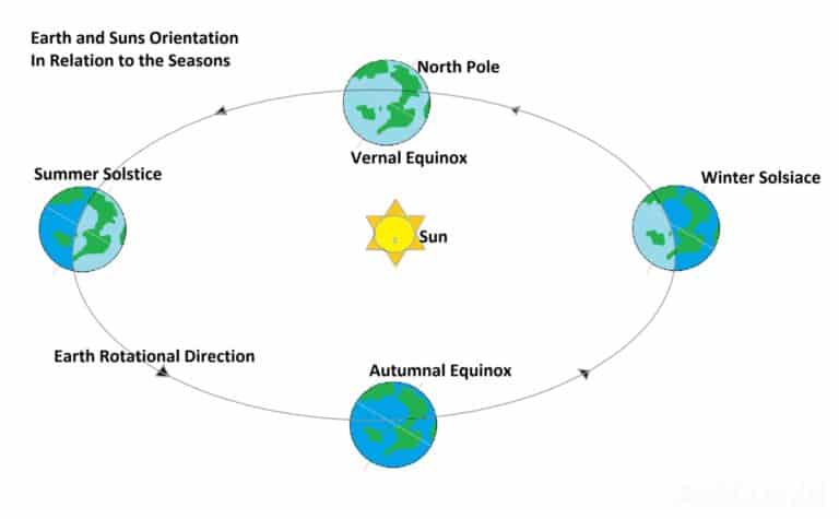
As the earth, on its slightly tilted axis, rotates around the sun on an elliptical orbit, the earth is transported closer and further away from the sun on its orbit due its axis tilt.
This means that when the Northern hemisphere is tilted away from the sun, it experiences winter and summer six months later as the earths axial tilt brings it closer to the sun.
The opposite occurs in the Southern Hemisphere, the spring and fall.
Earth’s climate is governed by the seasons, which are governed by the sun and given a time span as humanity tries to control and understand the universe.
Thus, we have the summer and winter solstice, the longest and shortest days of the year when the sun is closest and furthest from the earth.
To break up the wait for the solstice we have the vernal equinox and the autumnal equinox, these are the two days of the year the day and night are of equal length.
So, at a basic level we have been able to create a year made up of days, weeks and months, divided into three months cycles that correlate with the earth’s orbit.
Modern technology has allowed us to discover that the earth moves at 1000 miles per hour, rotating on its axis at a 15˚ tilt. This means that the earth rotates at 15˚ every hour making for 360˚ rotation every 24 hours.
Compass dials are graduated 0˚ to 360˚ – giving us the True North Paradox which is both 0˚ and 360˚. Once we achieved this, our ability to navigate experienced an exponential development.
Dead reckoning is a navigational example of how we can manage navigation with an understanding of time.
Moving from a fixed position on a bearing, if you can measure time, you can figure out:
- how far you can travel in a day,
- how long it will take to get to a certain point,
- and how to get back if you can tell the direction from which you came.
Now you are ready to explore the unknown world.
A Sundial
The sundial is arguably one the oldest and greatest advances in navigation, it allowed men to range further than ever before, plot new courses for the expansion of human discovery.
The first sundial can be traced back 3500 years BC and it was as simple as a stick in the ground.
This is still one of the simplest ways to establish a rough True North Bearing. It is accurate, as in true to bearing about 40% of the time.
It is still on point ad will take where you need to go.
For land navigation:
- you will have a direction as true as possible,
- you can guess a distance,
- judge the terrain you will have to cross,
- and use large catching features to make sure you get to where you are going.
Using aiming off to ensure you can hold to your next reference point and make the correct turn.
The Shadow Stick to Determine North
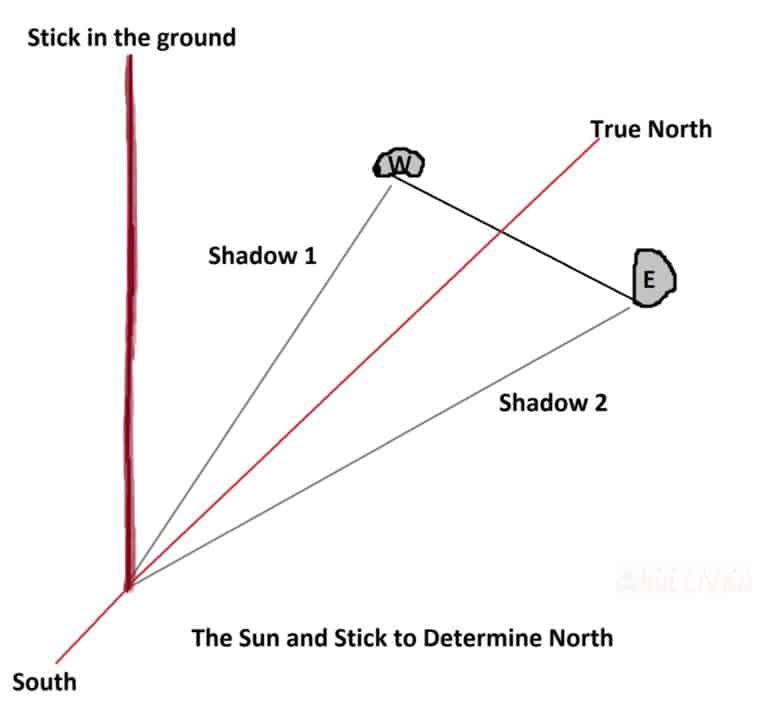
- Place a straight stick approximately 20 inches (50cm) long into the ground, make sure its sturdy and well planted.
- Take a reading mid-morning and place a stone at the tip of the first shadow. Mark this as East.
- The sun has risen in the east and is moving west – the first shadow is therefore East.
- Wait 20 minutes or long enough for the sun to move and cast the next shadow, mark it off with another stone. This is West.
- Draw a line between the two Stones and a line from the stick through the center of that line. That is True North. This hold for both Hemispheres.
- In the Northern Hemisphere the sun will at your back and at your front in the Southern Hemisphere.
Let’s take a look at how this happened…
The great snow fields of the Arctic are probably the only landmass that can be equated to the vastness of the world’s oceans and seas, great ranging emptiness, that can disorientate, mesmerize and bewilder the human mind, all at the same time.
Early explorers could only utilize landmarks and features to navigate between points, trading vessels hugged the coast for fear of steering into the big blue, yet humans knew there was more to see, and discover.
Treasure awaited those, brave enough to take on the unknown.
It soon became obvious to those brave souls that certain celestial regularities, like the sun and the stars would present themselves at certain times, which if read correctly would guide the navigator on his way.
Lines of latitude could be fixed using True north.
I can hear you say,” Huh?”
If North / South is a line of longitude, would it not make sense that your position is Longitude?
No, if the X line (N to S) is known, then you can fix your position all along that position giving you a line of latitude.

As North is known, East and West lead off at exactly 90˚, so the latitude is predictable based on True North reckoning.
So, no matter where in the world you are if you can determine Trye North you can determine your latitude as East and West.
This means that when you take a bearing North from Cairo and one from London, the North South position is true for each city, but what are the lines that run between these points? How does one measure them?
This was such a conundrum that various European governments put up huge rewards for anyone that could solve the problem of how to fix the lines of longitude between points.
Enter Time, early attempts at measurement failed due to accuracy but the humble sundial set the foundation for the answer to come, when the accurate chronometer was invented.
A time piece that was not susceptible to movement or handling.
In the beginning we became aware of our shadows and how they changed as the sun moved across the sky, alluding to the passing of time.
Placing a stone on the ground or a stick in the ground and mark off the shadow lengths will define the passing of time.
Even as we define our day in 24hours, minutes and seconds, the humble sundial would play its part in this development.
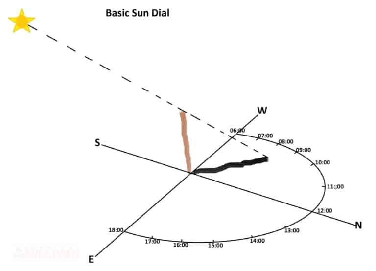
The sun moves across the sky East to West, rising at 06:00 and setting at 18:00. Obviously, these times change, for simplicity we will keep it as 06:00 to 18:00.
Use the shadow stick method to determine True North, take a mark on the shadow line. Approximately 20 minutes later, mark the new shadow line. Drawing a line between the two marks will indicate the celestial True North.
Aligning the east west line with the rising sun facing north, place your stick in the middle of your line with the Eastly rise.
As the shadow moves across the day, your arch, if evenly spaced at the 15˚ angles of separation, will show the hours of the day till noon, when the sticks shadow disappears briefly as the sun is overhead.
The shadow will begin its path again as the sun moves, now giving up the afternoon times, at the 15˚ marks you placed earlier.
The development of accurate time recording was vital to establishing lines of longitude, as they are separated by a time scale. Remember, no matter where you are in the world all lines of longitude converge over the North and South Poles.
It is for this reason we have time zones, with parts of the earth falling into night as other parts enjoy the sun.
As latitude has the equator defining the midway mark around the earth East to West, the longitude has the Prime Meridian to give it a fixed point to work with.
Once we had time to add to direction, it was possible to determine speed of movement, giving rise to the Dead Reckoning Method of Navigation.
Dead Reckoning allowed Christopher Columbus to sail West into the great unknown, reaching the Americas. More importantly, it allowed Columbus to sail back to Spain with a fair amount of accuracy.
Remember:
Speed = Distance divided by Time
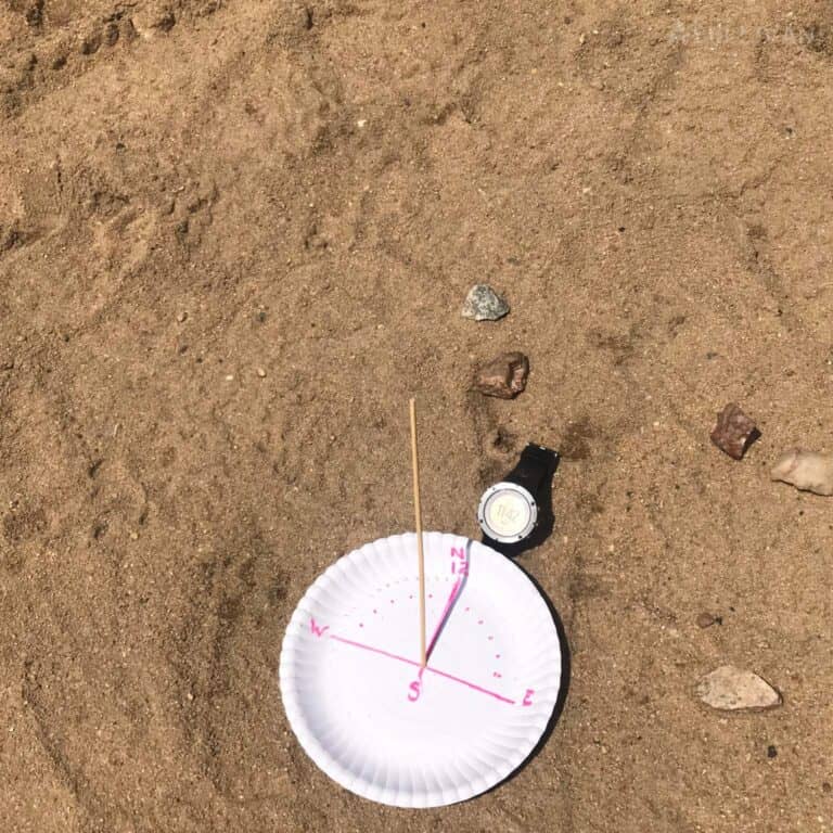
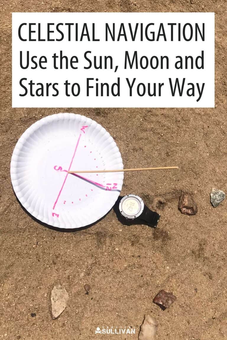
Making your Own Sundial
The best way to grasp and retain information is with practical application. With the above you are already geared to make your own and explore the basics of time and direction.
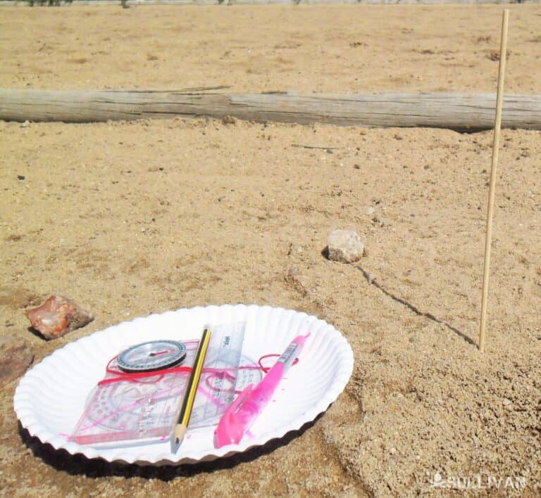
You Will Need
- A Compass
- Paper Plate
- A straw or Stick
- Marking Pen
- Pencil
- Ruler
- Watch to Verify your readings
This can be a portable sundial, when you move off.
You can also use a clear piece of level ground to build the sundial, you will have to redo it when you move off.
Use the compass to find magnetic North. If you know the declination, you can set your compass to true north.
If not, use the Shadow stick method above to determine true North, once you have the bearing place your compass on the sticks starting point.
The difference east or west in the North compass reading will give you the declination, in degrees.
Save this for use later when on the move – write it down.
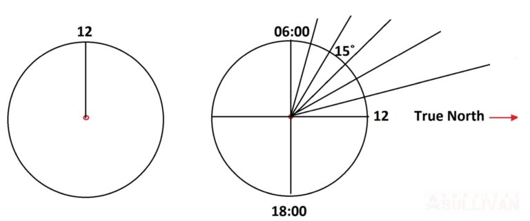
Draw a line on your plate, and mark it 12 o’clock or the noon line, which will be orientated on the True North line.
Place the shadow stick in a hole in the center of the plate, orientate your plate by rotating it to True North or till the shadow line meets the drawn line at noon.
No matter the size of the circle, it will always be 360˚ in circumference.
By drawing lines through the plate, you will have 4 x 90˚ angles at the center, from here you can figure out the angles that will represent the hours of the day as the sun casts the sticks shadow.
How to Use It
Picture 2
- Tilt the stick a little to the North, between 15 and 25 degrees to compensate for the Earth’s Tilt.
- The tilt will lengthen or shorten the shadow and give you a more accurate reading.
- Rotate the plate around the Stick to align with the True North at noon.
- Your ‘Watch Face” is marked off in 15˚ increments. These represent the hours of the day.
- As the shadow moves, with the movement of the sun they will cross each of these hour timelines.
- Plot out the sundial using the compass and watch to verify your findings.
Using a Time Piece to Find North
- Use an analog watch or draw a watch face using your digital watch as reference.
- Pint the hour hand in the direction of the sun.
- Draw a line through 12 O’clock.
- Mark the point that divides the space between the two points..
- Draw a line through the Watch Face.
- This is True North or Celestial North.
- In the Northern Hemisphere the Sun will be behind you and in the South the Sun will be in Front.
Navigate Using the Moon
The moon also holds the keys to navigation, its dependence on the sun for its illumination is exactly why we are able to discern direction under the right circumstances.
The moon is a satellite of earth which is visible with the naked eye in a fair amount of detail from almost anywhere on earth.
It ebbs and wanes like the tides it influences, sometimes it seems larger and at other times smaller, as the Sun and Moon move across the sky on an East to West orbit.
All of the moon phases are a direct result of the sun’s and the earth’s position relative to the moon as we orbit.
The New Moon occurs when the Sun and the moon are opposite each other, the Sun fully illuminates the Moon’s surface to its full brightness.
Depending where you are in the world, the Moon will be pointing to the Sun, either East or West. This is the East West Plain, the line that runs between these two celestial bodies.
Using this as your base it is possible to determine South and therefore North, as the opposing bearing.
The Crescent Moon is the most helpful in this regard, as the earth casts its shadow over the Lunar surface, revealing its tilt or the Axis of rotation.
This is a rough and ready Cardinal Point orientation, enough to keep you on course and give general bearings.
Using prominent land features, like the mountain saddle that stands in relief to the night sky, to aid your navigation will keep you on track.
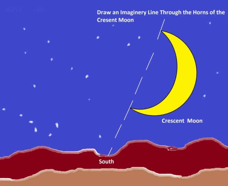
Setting your compass on your bearing and using land features to keep direction while moving, especially of you are moving fast, will be your catching feature, as in heading towards the saddle or your handrail. That feature that keeps you on your bearing.
If more accuracy is needed then the shadow method comes into play. As with the sun, the moon will cast shadows except on the eclipse, when the moon moves between the sun and earth.
When the shadows are shortest the moon will be at its highest point and brightest, this will be when the moon is due South. This is the exact North South Line.
Bear in mind that it will take up a large portion of your night as you wait out the hours.
The Moon phases are also directional indicators and follow the suns orbit, rising in the East and setting in the West.
Depending on the time of the year, the moon will rise in the South East and set in the South West or change and Rise in the North East and sets in the North West.
At Full Moon the Sun rises in the East as the Moon sets in the West. They are 180˚ opposite each other.
This article looked at the equinox and solstice seasonal occurrences that define the earth’s orbit around the Sun. As the earth orbits, the moon is influenced the same – not by seasons but by position.
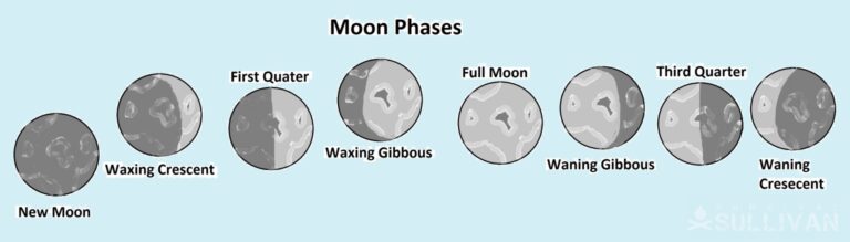
The phases have been broken down into months and days, defining the cardinal points for specific days. These were developed for military use and are quite complex, yet simple to utilize.
If you want to explore this more, take a look at the Lunar Calendar, it is a very useful tool, up to date and can be downloaded.
The moon illuminates the earth revealing only certain land-based features, look to the heavens for further guidance is necessary.
The Stars and Constellations
Since we could articulate our thoughts, we have wondered about the heavens.
Humanity’s thirst for knowledge and understanding has led us to space, the one fact the defines all humanity is the absoluteness of the cosmos.
Navigation developed independently in various cultures, yet they methods of determining direction are very similar.
The accumulated knowledge of the ages has been brought together to form the basis of modern navigation, still we must not lose sight of the history behind the vast knowledge base we have access to today.
The Northern Hemisphere
The North Star has been a celestial guide for millennia; however, it has not always been the same star. Due to the earth’s rotational axis, the earth itself has shifted over the same millennia.
The first star navigation references originate from the ancient Minoans who left written records around 3000 BC.
Minoans were sailors form Crete, trading in the Mediterranean Sea. Vikings, Polynesians, Indian fishermen, Persians and Chinese mariners all used the stars to navigate.
What is known is that vast amounts of knowledge were passed down in oral histories, before the written word.
The Polynesians were sailing the vast oceans of the Pacific and the Indian Oceans amongst others between 1500 and 1100 BC from the Easter Islands to the Marque Islands.
Incredible feats of navigation and sailing, not to mention mental fortitude and physical prowess. A testament to the human spirit. The same spirit that exists in everyone.
The ancient Egyptians used the North Star Thubon to align the pyramids, and we can assume that the star was used for navigation.
The Greek astronomer Ptolemy first recorded Polaris in 135 BC, in astrological charts, although not recorded it can also be assumed that Polaris, or the Nort Star was used for Navigation by seafarers.
Knowledge is gained not invented, and as the saying goes “There is noting new under the sun.”
Finding the North Star
Looking up at the celestial map unfolds before you, but how to find the way in the confusion of light. The answer is the constellations and the bright starts that inhabit them.
Luckily for us we have shortcuts to we can refer to, once you know, you know, right? Right!
Even if you don’t know, we will help you find out.
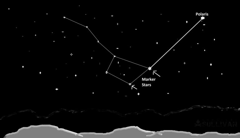
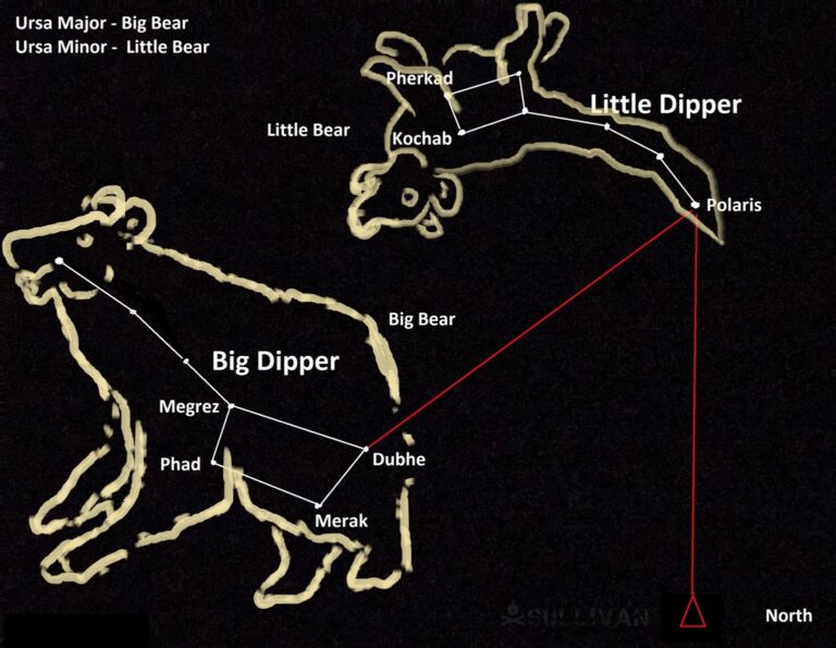
- You are looking at the Big Dipper in the Ursa Major Constellation or Big Bear
- The two marker stars indicated point to Polaris
- Polaris is the Celestial True North as it is aligned with the earth’s axis over the North Pole.
- Follow Polaris, trace a line down to the horizon to fix a point on land.
The human imagination is endless, and finds way to define the world we inhabit and control our destiny. So it is with the heavens, we find meaning in all things, and define them.
The Seasonal Visitor
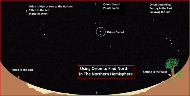
Orion’s Belt, is a constellation and is a seasonal visitor to both hemispheres over the course of a year. Being made up of multiple stars that will align with the horizon to give the navigator general and specific direction.
It is one of the easiest systems to identify with its three bright stars forming the belt. As Polaris is the celestial North so Orion’s Belt sits upon the celestial equator, allowing access to both hemispheres.
The Orion Constellation is made up of the three bright starts in the belt and four starts on the outer edges forming the Hour Glass configuration.
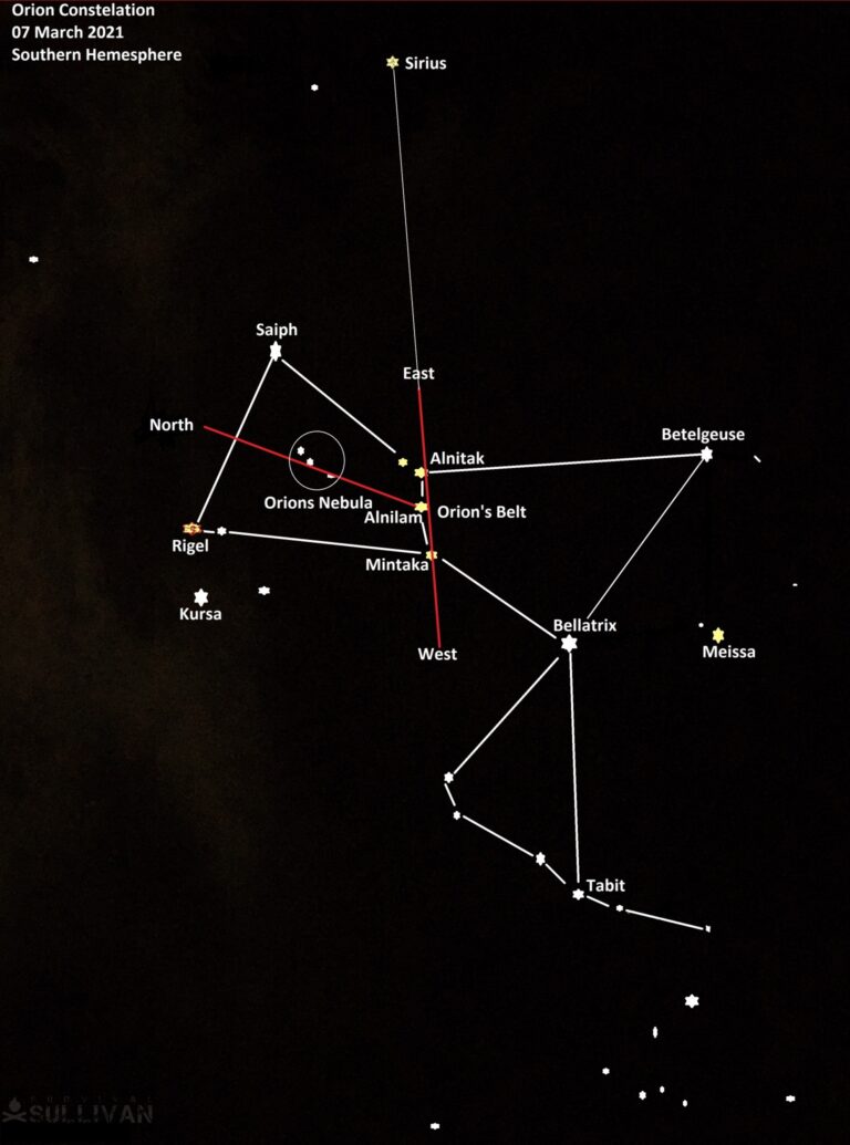
From the Egyptians, the Babylonians, the Aztecs and the Native Indian tribes of the Americas, the Orion Constellation has always held us enthralled.
Orion has guided builders of pyramids, and even city layouts. It has guided navigators for centuries, it is considered as the oldest documented constellation, around 32000 years old.
As stated earlier, Orion is on the celestial equator and follows the sun, rising in the east and setting in the west. In the Northern Hemisphere Orion is most visible during the winter from December through to April.
In the Southern Hemisphere the opposite is true, with Orion being the Souths summer guide.
The sword below the belt will point due South when Orion is at its highest. The first star to rise is called Mintaka, it will be the first star to set and will always rise within 1˚ of true east and true west, irrespective of the hemispheres.
The Southern Hemisphere
The Southern Hemisphere remained relatively unexplored by the North for centuries, or so it seemed. Early Persian and other Arab traders conducted successful voyages down the African continents coast, engaging in commerce and settlement.
Evidence has been found that even the Chinese had made contact with Africa, also to trade.
It’s not that Africa was unknown to Europe, but exploration beyond the Equator only came late in sailing’s history.
Circumnavigation would only become a reality in 1520 when Magellan circumnavigated the earth, on a voyage lasting almost 4 years.
In all this time, the Southern Cross has held its place in the heavens, providing the navigator with a solid reference point by which to plot a course.
How to Navigate Using the Southern Cross
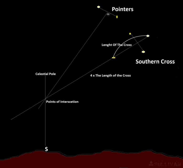
- Once you have identified the Southern Cross and the pointers, you can draw an imaginary line through the Cross, the Cross’s length.
- For a quick read, I use my fingers to measure the space, then measure out that same length 4 times.
- At the end of this length, draw another imaginary line to the horizon, this is your South.
- For a more accurate reading join the two pointers.
- Draw an imaginary line, forming a 90˚ angle between the two lines.
- Where they intersect, drop a line to the Horizon, giving you your South.
Early European sailors saw the Cross in the sky as a divine blessing, God’s guidance.
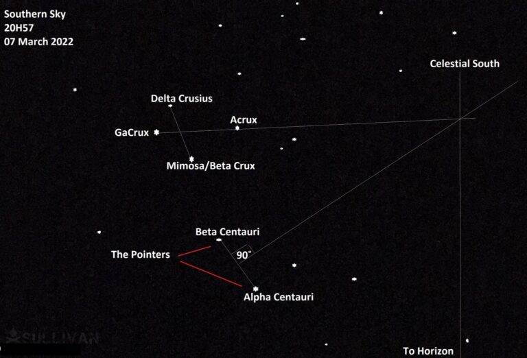
For the modern traveler, the Southern Cross is a part of the basic tool box of navigation. Alpha and Beta Centauri lead the way in pointing out the Southern Cross, they are called the pointer stars.
The Cross is made of Mimosa or Beta Crux, Ga crux, Acrux and Delta Crux. The length of the Southern Cross is measured through Ga Crux to Acrux, with Beta Crux and Delta Crux forming the cross section of the Cross.
Here’s a real-time picture of the Southern Cross demonstrating application of the method to find south:
There are a number of phone apps that can assist you today if you have an internet connection. They will help you identify the celestial plane you find yourself in and if you are using a celestial map, you can plot your position.
The electronic world we live has made access to information convenient, this article will give you an appreciation of the prowess of the early navigators, their knowledge and its application is as relevant today as it was then.
If the internet goes down or you are stranded without resources, how will you find your way, this simple to learn and apply knowledge will get you out, you can find your way home.
From the earliest times, navigators and guides have been held in high esteem, they are those who go forth into the world to discover new worlds.
Even as the world becomes more sophisticated, more electronic, the “old ways” still hold true. The Polynesian Voyaging Society in Hawaii is dedicated to the preservation of these skills.
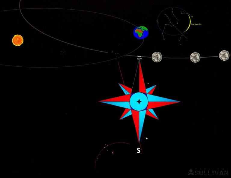
This beautiful Celestial Compass was designed by Master Navigator Nainoa Thompson.
It was used to navigate over 150 000 miles in 1976, to prove that traditional sailing boats and navigation could be used to support the idea that Polynesians traversed the world’s oceans way before the Europeans.
Not only that, but they circumnavigated the earth in 2013 to 2018. These voyages are the stuff of high adventure and discovery.
Key Takeaways
- The hemispheres will dictate what part of the celestial canopy you can view, so be sure you take that into account before you start.
- The Northern Hemisphere is governed by Polaris, the North Star. Polaris is in alignment with the earth’s axis.
- The Southern Hemisphere is governed by the Southern Cross. It is not aligned to the earth’s axis, so it moves across the sky at night as the earth rotates. Keep an eye out for that.
- The Sun gives us time and direction, it rises in the East and sets in the West.
- The Moon follows the sun and is a reliable indicator of direction.
- Shadows are cast by the Moon and the Sun, if used correctly, they will point to True North and True South.
Celestial Navigation is ancient and always available, with a solid foundation and regular practice it will keep on course and hold your direction. Now get out there and practice your skills!

Harrison Caine is a soldier, a hunter, a trained expert in hand-to-hand combat, hunting. He’s trained soldiers, fought wars, and provided defense services to refugees and U.S. officials. His experience in tough wilderness scenarios is unmatched
“…a stone at the tip of the first shadow. Mark this as East.”
No, the first stone marks WEST.
The SHADOW moves East as the Sun moves West.
Hey D,
This is the author’s reply to your comment:
“The sun rises in the east and sets in the west, So shadow in the morning will start in the west and end in the east, so the first shadow will be east as the shadow moves west so the angle increases to give you the next shadow stone mark west.”
Let me know if that clears things up.
That doesn’t sound right at all…. you say, “So shadow in the morning will start in the west and end in the east” then how can the first shadow be east if it ends in the east??